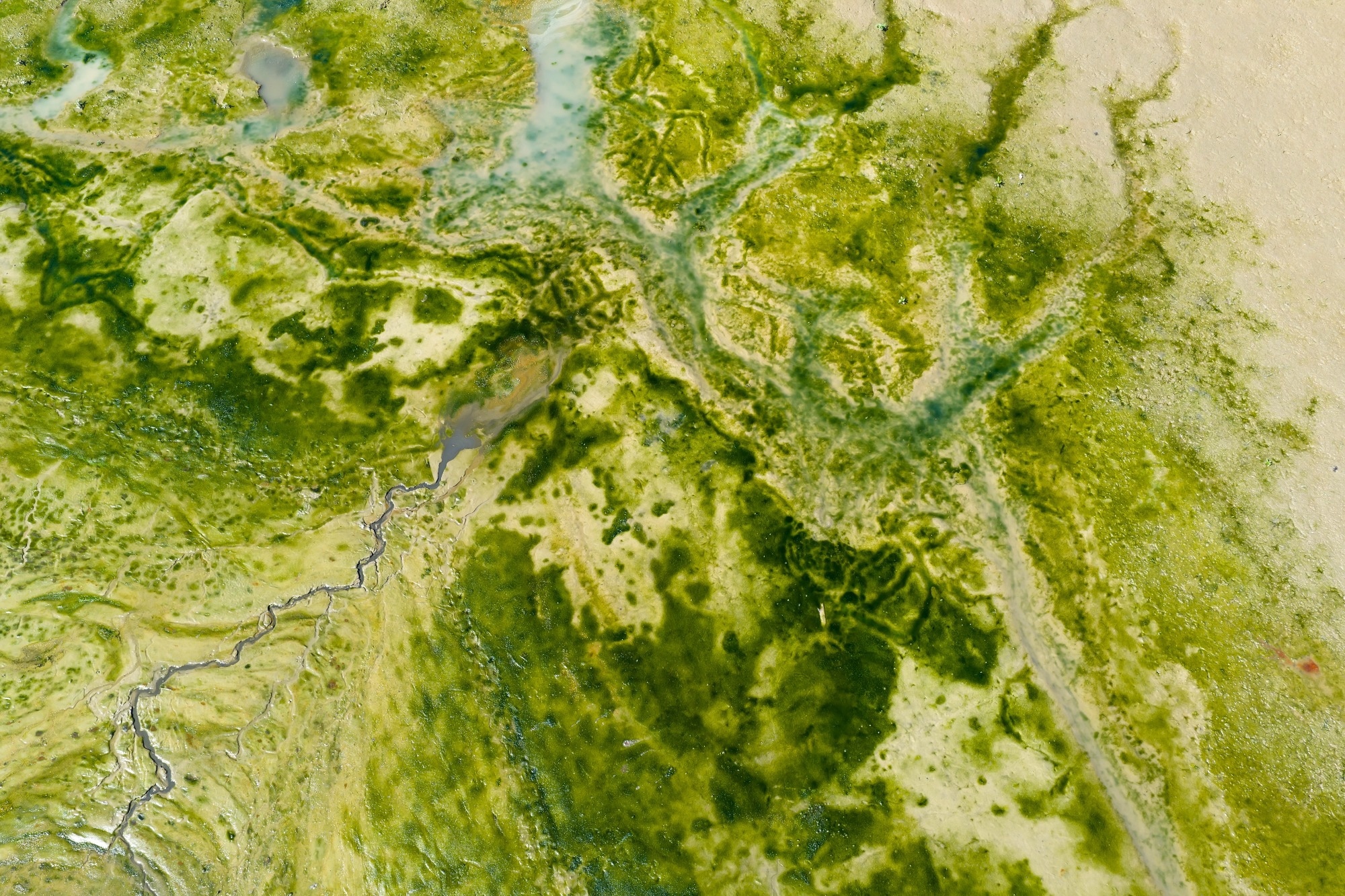
NASA satellite data combined with self-supervised AI helps detect harmful algal blooms earlier, mapping species-specific outbreaks in coastal waters to support faster sampling, public health alerts, and environmental response.
In an article published by the National Aeronautics and Space Administration (NASA), researchers have developed an artificial intelligence (AI) tool capable of detecting harmful algal blooms (HABs) in coastal waters.
Looking AheadNASA's new AI tool marks a significant advance in the fight against harmful algal blooms.
Fusing Multi- and Hyperspectral Satellite Data for Harmful Algal Bloom Monitoring With Self-Supervised and Hierarchical Deep Learning.
DOI:10.1029/2025ea004881, https://agupubs.onlinelibrary.wiley.com/doi/10.1029/2025EA004881NASA-developed AI Could Help Track Harmful Algae - NASA.
NASA satellite data combined with self-supervised AI helps detect harmful algal blooms earlier, mapping species-specific outbreaks in coastal waters to support faster sampling, public health alerts, and environmental response.
In an article published by the National Aeronautics and Space Administration (NASA), researchers have developed an artificial intelligence (AI) tool capable of detecting harmful algal blooms (HABs) in coastal waters. The study demonstrates how the tool fuses data from multiple satellites to map HABs in western Florida and Southern California. The researchers believe this system could significantly improve the speed and precision with which communities respond to these environmental threats.
HABs are not a new problem. Coastal communities, particularly in Florida and California, have battled them for decades. In Florida's Gulf of America waters, a species called Karenia brevis (K. brevis) is a well-known culprit, as it kills wildlife, degrades beaches, and makes the water unsafe for swimmers.
On the West Coast, Pseudo-nitzschia blooms have poisoned hundreds of dolphins, California sea lions, and other marine animals in recent years. Perhaps more alarming is that toxins from these algae can become airborne and trigger respiratory illness in humans who live or spend time near affected coastlines.
Beyond the ecological and health toll, severe blooms cost coastal economies in the United States tens of millions of dollars every year. Tourism, aquaculture, and fisheries all suffer when blooms force beach closures or contaminate seafood supplies.
Currently, managing the risk requires health agencies to conduct on-site water testing, a process that involves hours of travel by boat, manual sample collection, and lab analysis that can take a day or more. Knowing where to test before a bloom begins spreading adds another layer of difficulty. The National Oceanic and Atmospheric Administration (NOAA) does issue HAB forecasts in coordination with states and local partners during bloom seasons, but the process remains resource-intensive and slow.
How the AI System Works
The NASA team, comprising scientists Michelle Gierach and Kelly Luis from NASA's Jet Propulsion Laboratory (JPL), along with research data scientist Nick LaHaye of Spatial Informatics Group, developed a self-supervised machine learning system designed to learn patterns from multiple types of satellite data simultaneously.
The system was trained on satellite data gathered in 2018 and 2019. Field and laboratory measurements were then used to anchor the AI's pattern recognition with real-world context. Rather than requiring manually labelled datasets, the self-supervised approach allows the model to identify relationships across different data streams on its own.
The tool brings together data from five space missions or instruments. These include NASA's plankton, aerosol, cloud, and ocean ecosystem (PACE) satellite, which carries a hyperspectral sensor capable of identifying algal communities by their size, shape, and pigment. Another instrument, the tropospheric monitoring instrument (TROPOMI), detects the faint red glow that K. brevis emits during photosynthesis.
Initial results show the system can correctly identify and map HABs, including specific species, even in complex coastal waters that are swirling with sediment, plant matter, and runoff. "At the very least, a tool like this can help us know where and when to collect water samples as an algal bloom is starting," said Gierach.
Broader Potential and Next Steps
The implications of this tool extend well beyond the two regions tested in the study. The NASA team is now working to feed the system with data from additional coastlines and is expanding tests to freshwater bodies such as lakes. The long-term goal is to make the tool accessible to decision-makers within the next few years.
Download the PDF of this page here
Nadya Vinogradova Shiffer, lead program scientist at NASA Headquarters in Washington, noted that applying self-supervised AI to massive streams of satellite data is rapidly becoming a powerful approach for generating actionable ocean intelligence. The remark underscores a shift in how space-based observation is being used, not just to record environmental change, but to actively guide responses to it.
The tool also holds promise for fostering collaboration across scientific disciplines. Gierach has noted that it could drive new ways of conducting ocean science and delivering decision-support products to end users. Luis echoed this, stating the aim is to bridge technologies in ways that serve needs across sectors, ranging from aquaculture to tourism.
As climate patterns shift and warm waters increasingly favour algal growth, tools that can detect blooms earlier and with greater precision will become more valuable. This AI system, drawing on the strength of NASA's satellite fleet, represents a meaningful step toward putting that capability within reach of the communities that need it most.
Looking Ahead
NASA's new AI tool marks a significant advance in the fight against harmful algal blooms. By fusing data from multiple satellites and applying self-supervised machine learning, the system offers faster, broader, and more precise bloom detection than traditional methods allow. As the team continues to refine it with data from more coastlines and water bodies, the tool could soon give coastal communities, health agencies, and environmental managers a critical early-warning advantage, helping protect both public health and local economies from a threat that shows no signs of retreating.
Journal Reference
LaHaye, N. J., Luis, K. M., & Gierach, M. M. (2026). Fusing Multi- and Hyperspectral Satellite Data for Harmful Algal Bloom Monitoring With Self-Supervised and Hierarchical Deep Learning. Earth and Space Science, 13(5). DOI:10.1029/2025ea004881, https://agupubs.onlinelibrary.wiley.com/doi/10.1029/2025EA004881
NASA-developed AI Could Help Track Harmful Algae - NASA. (2026, May 20). NASA. https://www.nasa.gov/science-research/earth-science/nasa-developed-ai-could-help-track-harmful-algae/
Disclaimer: The views expressed here are those of the author expressed in their private capacity and do not necessarily represent the views of AZoM.com Limited T/A AZoNetwork the owner and operator of this website. This disclaimer forms part of the Terms and conditions of use of this website.