Heavy to very heavy rainfall is forecast over several regions, particularly along the west coast and in eastern and northeastern India.
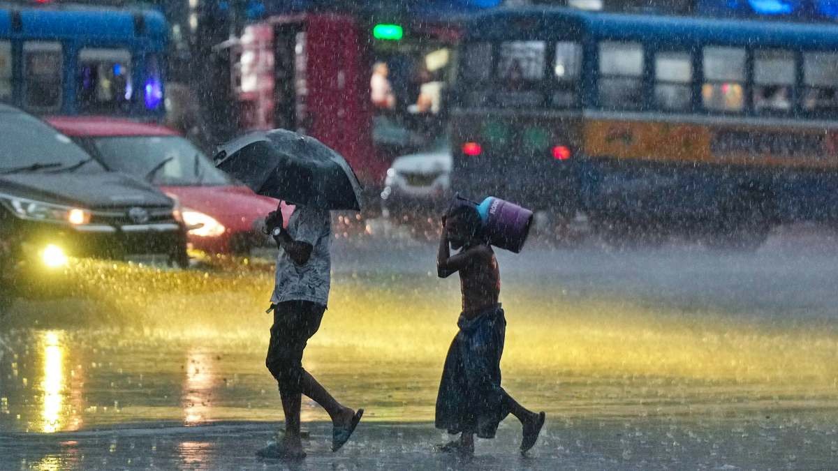
Very heavy rainfall was observed in Sub-Himalayan West Bengal, coastal Andhra Pradesh and the Andaman and Nicobar Islands, while heavy rain occurred over Bihar, eastern Uttar Pradesh, Assam, Arunachal Pradesh, Tamil Nadu and Telangana.
Meanwhile, heatwave conditions are expected to persist in parts of Vidarbha, Telangana and north coastal Andhra Pradesh, where the IMD has issued a heatwave warning.
Central India is likely to see little change initially, followed by a slight cooling trend later in the week.
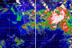
Meteorologists attribute the unsettled weather to a western disturbance over northern India, multiple cyclonic circulations over Haryana, Uttar Pradesh, Andhra Pradesh and Karnataka, and an active monsoon trough extending from Punjab to Bangladesh.
The India Meteorological Department (IMD) has issued widespread weather warnings for Friday, June 12, as an active western disturbance, advancing Southwest Monsoon and multiple cyclonic circulations combine to trigger thunderstorms, heavy rainfall and gusty winds across much of the country.
According to the IMD, the Southwest Monsoon has advanced further into Karnataka, Telangana, Andhra Pradesh, the remaining parts of Tamil Nadu and Puducherry, as well as parts of West Bengal and Bihar.
Read Full Story
Conditions remain favourable for the monsoon to push deeper into Maharashtra, Chhattisgarh, Odisha, Jharkhand, Uttar Pradesh and additional areas of Bihar and West Bengal over the next two to three days.
For Friday, a wet spell is expected to continue over Northwest India, with thunderstorms accompanied by lightning, gusty winds reaching 50-60 kmph and isolated hailstorms likely over Jammu and Kashmir, Himachal Pradesh, Punjab, Haryana, Uttarakhand and western Uttar Pradesh.
The IMD has placed much of North India under an Orange Alert, warning residents about potentially severe weather conditions. Dust storms are also likely at isolated locations in Rajasthan.
On Thursday, mobile phones buzzed across Delhi-NCR and several nearby regions in northern India as people received an emergency alert warning of a severe thunderstorm, accompanied by lightning, downpour and winds up to 100 kmph, in several parts of western Uttar Pradesh.
Agra, Aligarh, Baghpat, Bijnor, Ghaziabad, Hapur, Hathras, Mathura, Meerut, Muzaffarnagar, Saharanpur, and Shamli are the districts likely to be impacted by the storm. The message, broadcast at around 8.50 pm in both Hindi and English, flashed on smartphones with a startling notification tone, cautioning users about the possibility of a moderate to intense spell of rain and hail along with thunderstorms over the coming three hours.
Heavy to very heavy rainfall is forecast over several regions, particularly along the west coast and in eastern and northeastern India. Coastal Karnataka and Kerala are expected to receive intense rainfall, while heavy showers are also likely over coastal Andhra Pradesh, Odisha, Bihar, Jharkhand and Sub-Himalayan West Bengal.
The northeastern states of Assam, Meghalaya and Arunachal Pradesh are also under an Orange Alert due to the risk of heavy to very heavy rainfall.
The forecast follows significant weather activity recorded over the past 24 hours. Very heavy rainfall was observed in Sub-Himalayan West Bengal, coastal Andhra Pradesh and the Andaman and Nicobar Islands, while heavy rain occurred over Bihar, eastern Uttar Pradesh, Assam, Arunachal Pradesh, Tamil Nadu and Telangana. Conditions remain favourable for the monsoon to push deeper into Maharashtra. (Photo: Windy)
Thunderstorms with strong winds reaching 60-90 kmph were reported from parts of Odisha, Uttar Pradesh, Haryana, Jharkhand, Bihar, Punjab, Uttarakhand, West Bengal and the Andaman and Nicobar Islands.
Meanwhile, heatwave conditions are expected to persist in parts of Vidarbha, Telangana and north coastal Andhra Pradesh, where the IMD has issued a heatwave warning. Hot and humid conditions are also likely over Konkan and Goa and parts of Madhya Maharashtra.
Temperature trends are expected to vary across the country. Maximum temperatures over Northwest India are forecast to fall by 5-7 degrees Celsius until June 12 before gradually rising again. Central India is likely to see little change initially, followed by a slight cooling trend later in the week.
Meteorologists attribute the unsettled weather to a western disturbance over northern India, multiple cyclonic circulations over Haryana, Uttar Pradesh, Andhra Pradesh and Karnataka, and an active monsoon trough extending from Punjab to Bangladesh.
- Ends