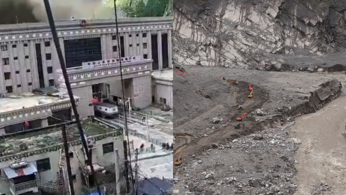
News world 'Like The Building Never Existed': Before-After Images Of Gyirong Border Port Will Leave You Stunned'Like The Building Never Existed': Before-After Images Of Gyirong Border Port Will Leave You StunnedPublished By :,Last Updated: September 03, 2026, 11:28 ISTWhat was once a functioning border crossing, with buildings, roads, vehicles and other infrastructure, now appears almost indistinguishable from the scarred valley floor.
Rapid ReadThe Gyirong Port on Nepal-Tibet border has been reduced to mud, rocks and debris.
What was once a functioning border crossing, with buildings, roads, vehicles and other infrastructure, now appears almost indistinguishable from the surrounding scarred valley floor.
Researchers calculated that the debris flow was travelling at about 19 metres per second, roughly 68 kmph, when it hit Gyirong Port.
By the time it reached the border crossing, it was no longer simply a landslide or flood.
News world 'Like The Building Never Existed': Before-After Images Of Gyirong Border Port Will Leave You Stunned
'Like The Building Never Existed': Before-After Images Of Gyirong Border Port Will Leave You Stunned
Published By :
,
Last Updated: September 03, 2026, 11:28 IST
What was once a functioning border crossing, with buildings, roads, vehicles and other infrastructure, now appears almost indistinguishable from the scarred valley floor.
Rapid Read
The Gyirong Port on Nepal-Tibet border has been reduced to mud, rocks and debris. (Image: X and AP)
The Gyirong border post on the Tibet-Nepal frontier has been reduced to such a vast expanse of mud, rock and debris that, in new aerial footage, it is difficult to imagine that a major border facility once stood there.
The devastation captured in drone imagery shared by geohazard researcher Iain Cameron offers a stark view of what happened on August 26, when an enormous ice-and-rock avalanche in the Himalayas transformed into a fast-moving debris flow and tore through Gyirong Port in Tibet. Cameron said the new footage “shows well the scale of the devastation", adding that “every piece of infrastructure has simply disappeared."
What was once a functioning border crossing, with buildings, roads, vehicles and other infrastructure, now appears almost indistinguishable from the surrounding scarred valley floor.
The new drone footage of the Gyirong border crossing location shows well the scale of the devastation.Montage 1: I’ve marked the approximate location of the CCTV camera on these before-and-after grabs, and a box showing the roof of an existing building where a makeshift HQ has… pic.twitter.com/Z2G6T3IJHW — Iain Cameron (@theiaincameron) September 2, 2026
And the latest casualty figures underline the human cost hidden beneath that landscape. As of Wednesday noon, 21 people had been confirmed dead in Tibet and 541 remained missing, according to the latest briefing by the government of China’s Xizang autonomous region. Rescuers have recovered 847 personal belongings from the disaster zone.
The numbers could still change as teams gain access to areas that remained buried or inaccessible for days.
Debris Flowing At 19 Metres Per Second
The border crossing was among the first major built-up areas struck after the torrent crossed into Tibet.
A Chinese Academy of Sciences study, reported by the South China Morning Post, provides an indication of just how little time people at the border facility had. Researchers calculated that the debris flow was travelling at about 19 metres per second, roughly 68 kmph, when it hit Gyirong Port. That was almost twice Usain Bolt’s average speed during his 100-metre world-record run and about 50 per cent faster than his recorded top speed.
In other words, running away from it was effectively impossible. The researchers described the catastrophe as a continuous chain of hazards: “ice avalanche to debris flow, then to mudslide and finally to flood." They said the interval between the initial avalanche and its impact on Gyirong Port was “extremely short", leaving very limited time for an effective response.
That finding adds context to the horrifying footage from the border crossing, where people can be seen attempting to flee moments before the wall of mud and water engulfs the area.
Seven Minutes From Mountain To Border
The scale and speed of the event become even more startling when its journey is reconstructed. The debris flow travelled roughly 22 km through the valley before reaching Gyirong Port in about seven minutes, according to an initial assessment reported by the South China Morning Post.
By the time it reached the border crossing, it was no longer simply a landslide or flood. It had become a moving mass of ice, boulders, sediment, mud and water capable of scouring the valley floor and demolishing substantial structures. Chinese authorities say debris deposits in the core disaster area now average around four metres in depth, with some locations buried under as much as 16 metres of material.
That helps explain why the aerial photographs are so jarring: the landscape has effectively been rebuilt by the disaster.
The G216 highway leading to Gyirong was also damaged, cutting off access to the worst-hit area and complicating the rescue operation. After days of repair work, road access was restored on Wednesday, allowing heavy machinery to finally enter the core zone. More than 2,300 rescuers have been mobilised, alongside hundreds of vehicles, drones and other specialised equipment.
But the drone images remain the clearest illustration of what the numbers alone cannot convey. The border post seems to have been swallowed by the mountain.
Cameron’s observation, that the footage makes it seem as though every piece of infrastructure has vanished, captures the extraordinary violence of the August 26 disaster better than almost any casualty figure can.
The first scientific reconstruction now suggests that, once the debris flow began, those caught directly in its path had virtually no chance of outrunning it. As the CAS researchers put it, the event moved so rapidly that the window for identifying the danger, transmitting a warning and making an emergency decision was extraordinarily small.
News18 Newsletter Handpicked stories, in your inbox A newsletter with the best of our journalism submit
Quick Answers Powered by Ask News18 What caused the massive ice-and-rock avalanche in the Himalayas? The disaster was triggered by a high-altitude glacier collapse on the Nepalese side of the Himalayas, where a massive chunk of ice broke away. Scientists believe this rock-and-ice avalanche fell into the Lhende River, temporarily blocking its flow and creating a landslide dam that subsequently gave way. Researchers are also examining whether unusually warm temperatures played a role in weakening the glacier and causing the collapse. Powered by Ask News18
About the Author Pragati Ratti Pragati is a News Editor at news18.com. Having headed the Business and Viral sections, Pragati now ideates, writes and edits long-form features and articles on national and global affairs. She ensures... Read More
First Published: September 03, 2026, 11:28 IST
Disclaimer: Comments reflect users’ views, not News18’s. Please keep discussions respectful and constructive. Abusive, defamatory, or illegal comments will be removed. News18 may disable any comment at its discretion. By posting, you agree to our Terms of Use and Privacy Policy Loading comments...