The reason is a single warm patch of the Pacific Ocean, and a phenomenon called El Nino.
The World Meteorological Organization (WMO), the United Nations body that tracks the planet’s weather, has confirmed that a strong El Nino is building fast.
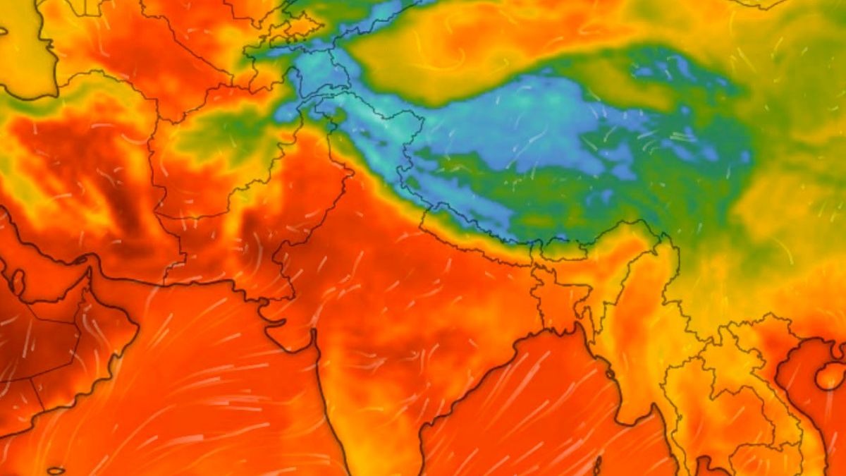
Read Full StoryWHY ONE OCEAN DECIDES SO MUCHEl Nino is the warm phase of a natural cycle called the El Nino Southern Oscillation, or ENSO.
For June–August 2026, WMO forecasts indicate significant shifts in rainfall patterns—a classic atmospheric response to the developing Pacific El Nio.
Above 0.5 degrees Celsius means El Nino.
This summer, two cities on opposite sides of the planet will look up at the same sky and meet two different fates. One will wait for rain that never comes. The other will watch it fall in sheets.
The reason is a single warm patch of the Pacific Ocean, and a phenomenon called El Nino.
The World Meteorological Organization (WMO), the United Nations body that tracks the planet’s weather, has confirmed that a strong El Nino is building fast. Between June and August 2026, it will redraw the world’s rainfall map, leaving some cities parched and others drenched.
Read Full Story
WHY ONE OCEAN DECIDES SO MUCH
El Nino is the warm phase of a natural cycle called the El Nino Southern Oscillation, or ENSO. Picture the Pacific running a fever.
Its central and eastern waters grow unusually warm, and that warmth shifts the winds that carry rain, steering storms away from some places and parking them over others.
For June–August 2026, WMO forecasts indicate significant shifts in rainfall patterns—a classic atmospheric response to the developing Pacific El Nio.
See which regions are likely to experience below-normal, normal or above-normal rainfall: https://t.co/isVXTJ27m4 pic.twitter.com/NL86C2CMUs— World Meteorological Organization (@WMO) June 6, 2026
WMO measures it with the Nino 3.4 index, a temperature reading from one stretch of the Pacific. Above 0.5 degrees Celsius means El Nino. This summer it is forecast to reach about 1.8 degrees Celsius, firmly strong.
THE CITIES THAT WILL WAIT FOR RAIN
India sits squarely in the dry half of the forecast. WMO models, backed by the India Meteorological Department (IMD), point to a below-normal monsoon, around 90 per cent of the long period average, the decades-long benchmark for a normal year.
From Delhi and Mumbai to Bengaluru and Hyderabad, the rains are likely to fall short. Only the northeast may be spared the worst.
India is not alone. In the Greater Horn of Africa, where Addis Ababa leans on its summer rains, a drier season looms, as it does for Accra and Lagos near the Gulf of Guinea.
Recife and Fortaleza in northeast Brazil are tilted dry, and so is most of Australia, including Sydney, Melbourne and Perth.
THE CITIES THAT WILL BE DRENCHED
El Nino does not switch the world off. It moves the water. The strongest wet signal sits over the open Pacific east of the date line, with the normally arid coast of Ecuador among the few land strips likely to catch heavier rain.
On land, southern Africa shows the clearest tilt towards a wetter season. Cities such as Johannesburg and Harare may see more rain than a normal winter brings.
The WMO's advice is plain: prepare now.
As Secretary-General Celeste Saulo puts it, an El Nino's footprint reaches far beyond the Pacific, touching food, water and livelihoods across whole regions.
For the cities in its path, the next three months will tell two very different stories.
- Ends