India’s southwest monsoon continues to battle a prolonged slowdown, with the all-India rainfall deficit widening to 42% between June 4 and June 18, according to the latest India Meteorological Department (IMD) data.
Meanwhile, much of central India, Maharashtra, Gujarat and the monsoon core zone remain relatively cloud-free.
Western disturbances have repeatedly disrupted the normal monsoon flow, preventing moisture-laden winds from penetrating deep into central and northwestern India.
Parts of central India, including Vidarbha and Madhya Pradesh, are also waiting for a meaningful monsoon revival.
Unless a robust low-pressure system develops and moisture transport strengthens significantly over the next week, the rainfall deficit could persist into late June, making a full recovery increasingly difficult.
India’s southwest monsoon continues to battle a prolonged slowdown, with the all-India rainfall deficit widening to 42% between June 4 and June 18, according to the latest India Meteorological Department (IMD) data.
The country received just 42.1 mm of rain against the normal 72.2 mm during the period, highlighting the growing challenge facing the season barely two weeks after its onset.
Read Full Story
Rainfall remains far below normal across large parts of the country.
The latest district-wise rainfall map paints a worrying picture. Large swathes of central, eastern and peninsular India remain in the deficient (-20% to -59%) or large deficient (-60% to -90%) categories. Only isolated pockets in northwest India and parts of the western Himalayan region have reported excess rainfall.
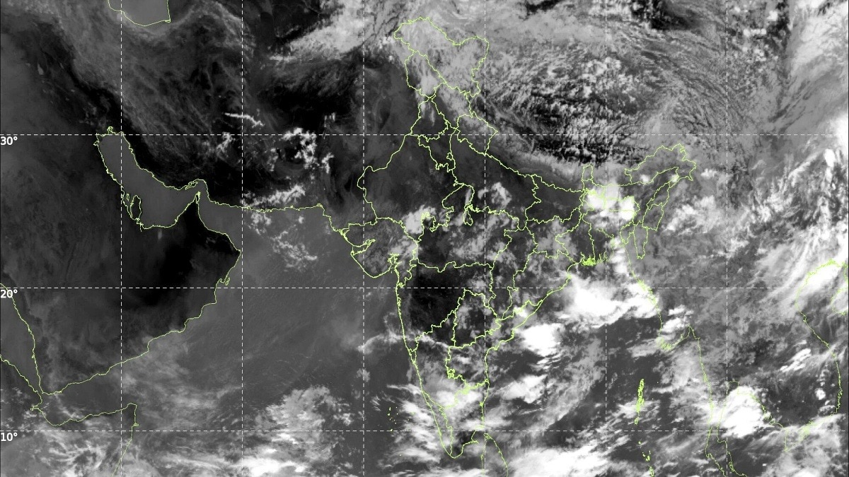
Satellite imagery from INSAT-3DS on June 18 explains why the recovery remains difficult. The image shows the densest cloud mass concentrated over the western Himalayas and adjoining northern regions, linked to an active western disturbance.
Meanwhile, much of central India, Maharashtra, Gujarat and the monsoon core zone remain relatively cloud-free. The Arabian Sea branch appears weak, with limited deep convection along the west coast, while the Bay of Bengal branch is producing only scattered thunderstorm clusters over eastern and northeastern India.
Meteorologists say the monsoon circulation is still struggling to establish itself across the country. The monsoon has remained largely stagnant for days as upper-level atmospheric conditions continue to suppress its northward advance.
Western disturbances have repeatedly disrupted the normal monsoon flow, preventing moisture-laden winds from penetrating deep into central and northwestern India. Reuters had earlier reported that below-average rainfall was likely over much of the country due to these disruptions.
The rainfall shortfall is already being felt on the ground. Maharashtra has recorded severe deficits, while Mumbai is experiencing one of its driest Junes in over a decade, forcing authorities to impose water restrictions.
Parts of central India, including Vidarbha and Madhya Pradesh, are also waiting for a meaningful monsoon revival.
The challenge now is timing. With June entering its second half, the monsoon needs a strong surge from both the Arabian Sea and Bay of Bengal to erase the accumulated deficit. However, the current satellite picture suggests that such a widespread revival is not yet underway.
Unless a robust low-pressure system develops and moisture transport strengthens significantly over the next week, the rainfall deficit could persist into late June, making a full recovery increasingly difficult.
- Ends