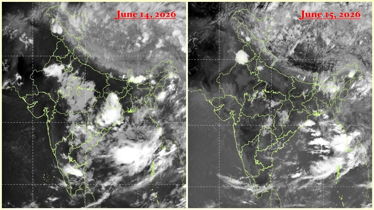
Instead of the familiar broad cloud shield associated with an active monsoon, much of peninsular and central India appears unusually clear.
The slowdown comes despite the monsoon making further advances into parts of Karnataka, Telangana, Andhra Pradesh, Maharashtra and central India in recent days.
At the centre of the problem is the westerly jet stream, a fast-moving river of air in the upper atmosphere that has shifted much farther south than normal.
Forecast models suggest rainfall activity could gradually improve later this week as the jet stream pattern weakens and monsoon circulation begins to reorganise.
Until then, much of India will continue to wait for the widespread rains that typically define the heart of the southwest monsoon season.
India's southwest monsoon appears to have all but disappeared from satellite imagery, with large parts of the country witnessing a dramatic collapse in rainfall activity just days after the seasonal rains advanced into southern and central regions.
Fresh data from the India Meteorological Department (IMD) shows that India has received only 19.2 mm of rainfall against a normal of 53.7 mm between June 4 and June 15, translating into a nationwide rainfall deficit of 64%.
Read Full Story
The rainfall departure map paints a worrying picture, with vast stretches of central, southern and eastern India coloured in yellow and red shades, indicating deficient to large deficient rainfall.
The situation is even more striking in satellite imagery from INSAT-3DS captured on June 15. Instead of the familiar broad cloud shield associated with an active monsoon, much of peninsular and central India appears unusually clear.
The most significant cloud activity is concentrated over the Himalayas, northeastern India and areas north of the Indo-Gangetic plains, while the Arabian Sea branch of the monsoon looks weak and fragmented.
WHY IS INDIAN MONSOON STRUGGLING IN 2026?
The slowdown comes despite the monsoon making further advances into parts of Karnataka, Telangana, Andhra Pradesh, Maharashtra and central India in recent days. Meteorologists say the problem is not a lack of moisture over the surrounding seas but a large-scale atmospheric tug-of-war unfolding several kilometres above the surface.
At the centre of the problem is the westerly jet stream, a fast-moving river of air in the upper atmosphere that has shifted much farther south than normal.
This unusual displacement is interfering with the upper-level easterly jet, one of the key engines that helps sustain the monsoon circulation over India.
Under normal conditions, the easterly jet promotes rising air and widespread thunderstorm development across the subcontinent.
However, the stronger-than-usual westerly winds are suppressing this mechanism, creating conditions that discourage cloud formation and rainfall despite abundant moisture being present in the Arabian Sea and Bay of Bengal.
The result is a monsoon that has technically advanced on the map but has struggled to deliver meaningful rainfall over large regions. Weather experts describe the current phase as a temporary but significant "monsoon pause" driven by upper-atmospheric dynamics rather than oceanic conditions.
Forecast models suggest rainfall activity could gradually improve later this week as the jet stream pattern weakens and monsoon circulation begins to reorganise. Until then, much of India will continue to wait for the widespread rains that typically define the heart of the southwest monsoon season.
- Ends