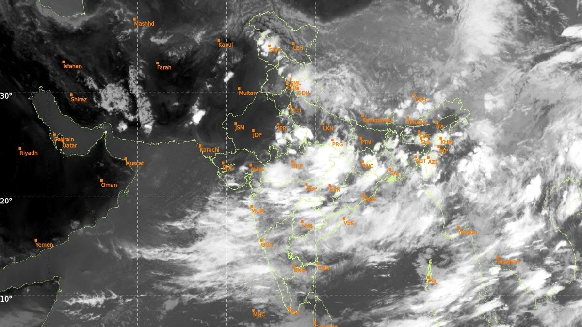
Satellite imagery from Isro on Wednesday captured a dramatic surge in monsoon cloud cover sweeping across northern India, signalling a decisive revival of the southwest monsoon after one of the driest Junes in more than a century.
The rapid build-up of clouds has already translated into widespread rainfall across several northern states.
According to forecasts, the onset spell of the southwest monsoon is expected over Delhi-NCR, Chandigarh, more parts of Haryana and Punjab later Wednesday night through Thursday afternoon.
The latest satellite imagery indicates moisture-laden winds from both the Arabian Sea and the Bay of Bengal converging over northern India.
Meanwhile, Rajasthan, one of the states worst affected by the delayed monsoon, remains outside the active rain belt for now.
Satellite imagery from Isro on Wednesday captured a dramatic surge in monsoon cloud cover sweeping across northern India, signalling a decisive revival of the southwest monsoon after one of the driest Junes in more than a century.
The latest thermal infrared images show dense cloud bands stretching from central India into the Indo-Gangetic plains, powered by an active monsoon circulation and fresh weather systems over the Bay of Bengal. The rapid build-up of clouds has already translated into widespread rainfall across several northern states.
Read Full Story
The India Meteorological Department (IMD) said the southwest monsoon has advanced into most parts of west Uttar Pradesh and some parts of east Haryana on July 1, following widespread rain and thunderstorm activity over the region.
The advance marks another significant step in the monsoon's northward march after weeks of sluggish progress that left large parts of the country facing severe rainfall deficits, heatwave conditions and delayed kharif sowing.
Weather experts now expect the monsoon to continue its rapid advance over the next 24 hours.
According to forecasts, the onset spell of the southwest monsoon is expected over Delhi-NCR, Chandigarh, more parts of Haryana and Punjab later Wednesday night through Thursday afternoon. The rain is likely to begin with thunderstorms and gusty winds before becoming more widespread as the monsoon establishes itself across the region.
The latest satellite imagery indicates moisture-laden winds from both the Arabian Sea and the Bay of Bengal converging over northern India. At the same time, the monsoon trough has begun shifting closer to its normal position, creating favourable conditions for sustained rainfall across the plains.
Residents of Delhi-NCR, which endured repeated heatwaves and uncomfortable humidity through June, are likely to experience a noticeable drop in temperatures once the monsoon sets in. Meteorologists expect scattered showers initially, followed by fairly widespread moderate to heavy rainfall over the next few days.
Meanwhile, Rajasthan, one of the states worst affected by the delayed monsoon, remains outside the active rain belt for now. However, satellite images show cloud masses rapidly pushing westward, with forecasters saying conditions are becoming increasingly favourable for the monsoon to enter more parts of the state in the coming days.
The revival comes at a crucial time. India ended June with a 40% rainfall deficit, making it the fifth-driest June since 1901, while kharif sowing has slowed sharply due to inadequate soil moisture.
Meteorologists say the first half of July will be critical for narrowing the rainfall deficit. With two low-pressure systems expected to strengthen monsoon circulation, widespread rains are forecast across north, central and western India, offering much-needed relief to farmers and millions waiting for the season's arrival.
- Ends