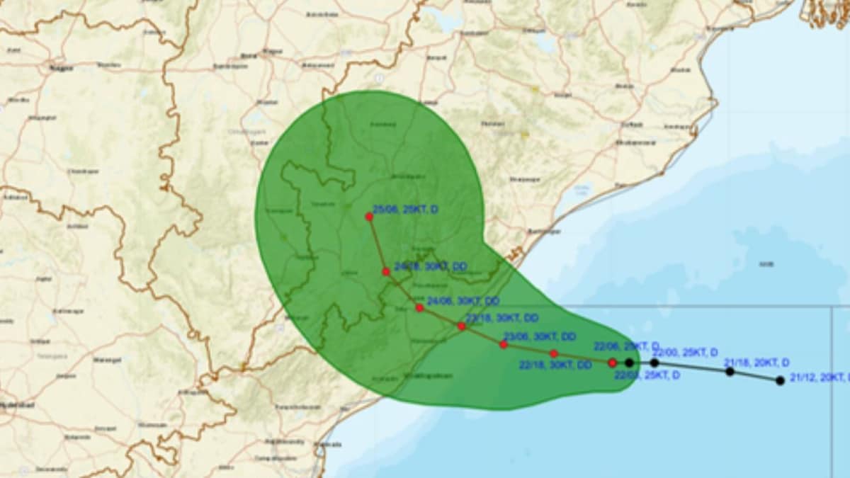
It is moving west-northwestwards and is likely to bring heavy to very heavy rainfall to several coastal and southern districts.
Odisha is expected to face the main impact of the weather system, with several districts already reporting heavy rain.
Ferry services between Satapada and Jahnikuda in Chilika Lake have also been suspended until September 25 as a precaution.Coastal Andhra Pradesh is also expected to be affected as the system moves towards the coast.
The IMD has said the deep depression will cross between Visakhapatnam in Andhra Pradesh and Gopalpur in Odisha.The weather office has warned of squally conditions and strong winds along and off the south Odisha-north Andhra Pradesh coast.
The names are decided in advance by countries in the region and are used when a weather system strengthens into a cyclone.
The Depression over Westcentral & adjoining Northwest Bay of Bengal, moved westwards with speed 08 kmph during past 06 hours and lay centred at 1130 hrs IST of today, the 22nd September, 2026, over the same region near latitude 17.9°N and longitude 85.8°E, about 180 km… pic.twitter.com/qjVYCBBzoq
— India Meteorological Department (@Indiametdept) September 22, 2026
A weather system over the Bay of Bengal has intensified into a deep depression and is moving towards the coast, with Odisha and Andhra Pradesh expected to see heavy rain and strong winds.The India Meteorological Department (IMD) has forecast that t he system will cross the north Andhra Pradesh-south Odisha coast between Visakhapatnam and Gopalpur.The system is expected to cross the coast between the night of September 23 and the early hours of September 24. It is moving west-northwestwards and is likely to bring heavy to very heavy rainfall to several coastal and southern districts. Odisha is expected to face the main impact of the weather system, with several districts already reporting heavy rain. The state government has stepped up preparations for flooding, waterlogging, landslides and mudslides in vulnerable areas.Schools in Khurda, Jagatsinghpur, Ganjam and Gajapati have been ordered to remain closed on September 24. Schools in Malkangiri have also been shut until September 24, while Anganwadi centres in the affected areas will remain closed. Kalahandi, Nabarangpur, Koraput and Malkangiri are also under a red alert for September 24-25.Odisha Chief Secretary Anu Garg said collectors of 11 districts have been put on high alert. Authorities have prepared shelters and taken steps to restrict movement on vulnerable routes. Ferry services between Satapada and Jahnikuda in Chilika Lake have also been suspended until September 25 as a precaution.Coastal Andhra Pradesh is also expected to be affected as the system moves towards the coast. The IMD has said the deep depression will cross between Visakhapatnam in Andhra Pradesh and Gopalpur in Odisha.The weather office has warned of squally conditions and strong winds along and off the south Odisha-north Andhra Pradesh coast. Wind speeds could reach up to 75 kmph during the period of the system's movement towards the coast.The IMD had said the depression was moving west-northwestwards and was expected to intensify into a deep depression over the west-central and adjoining northwest Bay of Bengal before crossing the coast.The name 'Arnab' has been assigned by Bangladesh as part of the list of names used for cyclones in the North Indian Ocean. The names are decided in advance by countries in the region and are used when a weather system strengthens into a cyclone.