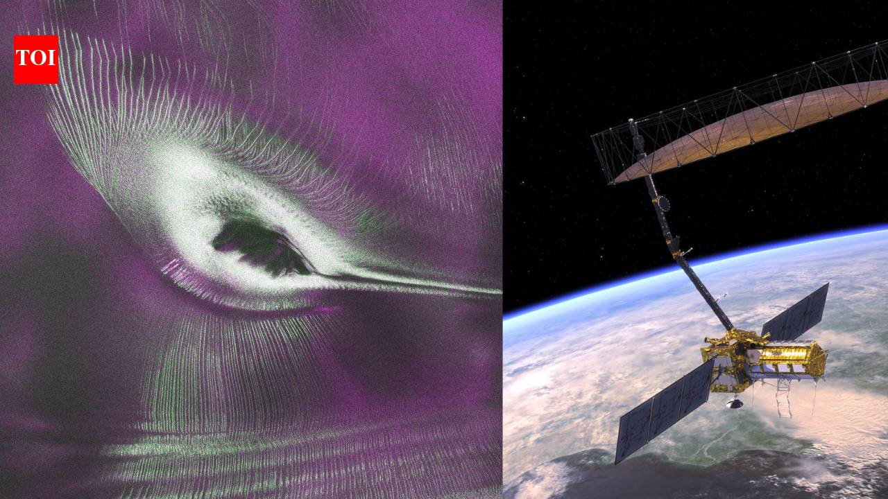
The striking image was captured by the NASA-ISRO Synthetic Aperture Radar (NISAR) satellite using its L-band radar, which can penetrate snow and image properties of the ice that conventional optical satellites cannot see.
Rather than creating a scientific curiosity alone, researchers say the image demonstrates how radar can expose hidden glacier structures that help explain how Antarctic ice deforms, fractures, and ultimately contributes to rising sea levels.
As the ice slowly flows around it, stresses build within the ice sheet, producing long cracks that spread across the surface.
Unlike ordinary satellite photographs, NISAR’s radar records how polarized microwave signals interact with the snow and ice.
Smooth ice reflects radar differently from fractured ice, allowing scientists to assign different colors to the returned signals and reveal structures hidden beneath the surface.
Nisar image of Nunatak Zaterjavshijsja, a mountaintop in East Antarctica, poking out amid a stream of ice flowing northeast to the ocean | NASA
Nisar image of Nunatak Zaterjavshijsja, a mountaintop in East Antarctica, poking out amid a stream of ice flowing northeast to the ocean | NASA
The “hummingbird” is actually a glacier flowing around a mountain
Radar reveals details invisible to ordinary cameras
NISAR undergoing tests | Wikimedia Commons
Why hidden fractures matter for climate research
At first glance, it looks like a hummingbird frozen in Antarctica’s ice, but look closer, and the “bird” transforms into something even more remarkable: a mountain buried within a glacier, surrounded by fractures that reveal how one of Earth’s largest ice sheets moves under immense pressure. The striking image was captured by the NASA-ISRO Synthetic Aperture Radar (NISAR) satellite using its L-band radar, which can penetrate snow and image properties of the ice that conventional optical satellites cannot see. Rather than creating a scientific curiosity alone, researchers say the image demonstrates how radar can expose hidden glacier structures that help explain how Antarctic ice deforms, fractures, and ultimately contributes to rising sea levels. According to NASA , the feature is centered on Nunatak Zaterjavshijsja, a rocky mountaintop protruding through East Antarctica’s ice sheet, where flowing ice is forced to split and fracture as it moves toward the ocean. The image’s dark central “body” is the exposed summit of Nunatak Zaterjavshijsja. What resembles wings and feathers are networks of deep crevasses radiating through the surrounding glacier, while the apparent tail is a stream of ice stretching northeast toward the coast.These fractures form because the mountain acts as an obstacle in the glacier’s path. As the ice slowly flows around it, stresses build within the ice sheet, producing long cracks that spread across the surface. Unlike ordinary satellite photographs, NISAR’s radar records how polarized microwave signals interact with the snow and ice. Smooth ice reflects radar differently from fractured ice, allowing scientists to assign different colors to the returned signals and reveal structures hidden beneath the surface. NASA scientists nicknamed the image “the hummingbird” because of its striking resemblance to the tiny bird. Optical satellites can record only the surface appearance of Antarctica, where snow often masks the complex structure below. Radar behaves differently. Depending on its wavelength, it can partially penetrate snow and ice before reflecting back to the spacecraft, revealing internal properties that conventional cameras cannot detect. NISAR combines two synthetic aperture radar systems operating at different wavelengths, making it the first satellite to carry both L-band and S-band radar instruments. In this case, the longer-wavelength L-band radar captured subtle differences between smooth glacier surfaces and highly fractured regions surrounding the mountain. According to NASA signal analysis engineer Seongsu Jeong, the data provide rich insight into glacier movement because the radar is able to observe “what’s hidden beneath the surface.” The image itself was generated from measurements collected during instrument testing in August 2025, before the satellite began publicly releasing calibrated scientific data in July 2026. Understanding where glaciers crack is far more than an exercise in creating beautiful satellite imagery. Crevasses influence how quickly glaciers move, how meltwater travels through the ice, and how rapidly ice can eventually reach the ocean. Those processes directly affect projections of future sea-level rise. Radar observations also allow scientists to monitor changes over time, revealing whether fracture networks expand, shrink or shift as climate conditions evolve. Because NISAR will repeatedly map nearly all of Earth’s land and ice surfaces, researchers expect the mission to provide an unprecedented record of glacier dynamics across Antarctica and Greenland over the coming years.The colorful “hummingbird” therefore represents more than a fortunate optical illusion. It demonstrates how advanced radar technology can transform seemingly featureless ice into a detailed map of stresses, fractures, and hidden structures that are invisible to the naked eye. As NISAR continues collecting data across the polar regions, scientists expect images like this to improve models of glacier behavior and strengthen predictions of how Earth’s great ice sheets may respond in a warming climate.